-->

Welcome to our Coding with python Page!!! hier you find various code with PHP, Python, AI, Cyber, etc ... Electricity, Energy, Nuclear Power

Monday, 9 March 2020

Coronavirus Disease 2019 (COVID-19) in the U.S. States Reporting Cases of COVID-19 to CDC* Live Updates: 09/03/2020

This page will be updated regularly at noon Mondays through Fridays. Numbers close out at 4 p.m. the day before reporting.

CDC is responding to an outbreak of respiratory illness caused by a novel (new) coronavirus. The outbreak first started in Wuhan, China, but cases have been identified in a growing number of other locations internationally, including the United States.


COVID-19: U.S. at a Glance*
Total cases: 423
Total deaths: 19
States reporting cases: 35 (includes District of Columbia)
* Data include both confirmed and presumptive positive cases of COVID-19 reported to CDC or tested at CDC since January 21, 2020, with the exception of testing results for persons repatriated to the United States from Wuhan, China and Japan. State and local public health departments are now testing and publicly reporting their cases. In the event of a discrepancy between CDC cases and cases reported by state and local public health officials, data reported by states should be considered the most up to date.


COVID-19: Cases in the United States Reported to CDC*†‡
COVID-19: Cases in the United States Reported to CDC*†
Travel-related 72
Person-to-person spread 29
Under Investigation 322
Total cases 423
* Data include both confirmed and presumptive positive cases of COVID-19 reported to CDC or tested at CDC since January 21, 2020, with the exception of testing results for persons repatriated to the United States from Wuhan, China and Japan. State and local public health departments are now testing and publicly reporting their cases. In the event of a discrepancy between CDC cases and cases reported by state and local public health officials, data reported by states should be considered the most up to date.

† CDC is no longer reporting the number of persons under investigation (PUIs) that have been tested, as well as PUIs that have tested negative. Now that states are testing and reporting their own results, CDC’s numbers are not representative of all testing being done nationwide.

‡ As of March 8, 2020 1,707 patients had been tested at CDC. This does not include testing being done at state and local public health laboratories, which began this week.


States Reporting Cases of COVID-19 to CDC*


Sunday, 26 January 2020

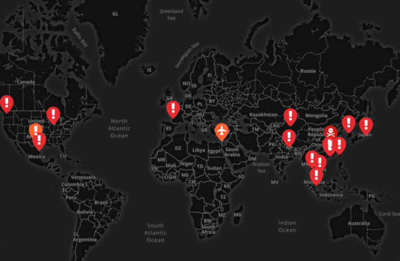
Coronavirus reported across the globe, 56 killed so far - interactive map


Thousands of people are thought to have been infected in China and around the world.


A map of the deadly Coronavirus outbreaks (photo credit: SCREENSHOT / MAPHUB)
A map of the deadly Coronavirus outbreaks
(photo credit: SCREENSHOT / MAPHUB)

56 people in China have died and more than 2,000 have been infected by the dangerous coronavirus, and now, several Israelis have reportedly been hospitalized in Sheba Medical Center with the suspicion that they may have caught the frightening virus.
The Israelis had returned from China not long ago.
35 million people, greater than the population of Texas and nearly the population of the state of California, have been placed under quarantine, as the Chinese authorities locked down 12 cities in an attempt to halt the spreading of the deadly coronavirus, The New York Times reported on Sunday.

According to the Times, more than 900 cases of the virus have been confirmed in China, and 26 people have died as of late Friday night. As of Saturday, more than a thousand cases of the virus were reported in China and at least 41 people have died.

Patients carrying the virus were also detected in Hong Kong, Taiwan, Japan, Vietnam and Thailand.

France reported its first three cases late Friday night. An analysis by Imperial College London estimated a total of 1,723 cases in the Chinese city of Wuhan, the center of the outbreak, last week.


The only lab in China designated for researching some of the world's most dangerous pathogens is located in the city, 20 miles away from the Huanan Seafood Market which is believed to be the outbreak's epicenter.

According to The Daily Mail, Chinese scientists warned in 2017 that a SARS-like virus might escape the lab, possibly infecting the area's residents.

Starbucks closed all of its outlets in Hubei province for the week-long Lunar Chinese New Year, Reuters reported. 

Australia declared on Saturday its first confirmed case of the Wuhan coronavirus in the state of Victoria, with the patient hospitalized in stable condition in a suburb of Melbourne, Victoria health officials said on Saturday.

According to Financial Review, six people in Australia were in quarantine on Friday and tested for the virus.

Malaysia said 
on Saturday that it had confirmed three cases of coronavirus infection, according to Reuters. Health Minister Dzulkefly Ahmad said the three individuals infected were related to the 66-year-old man that was confirmed by Singaporean health authorities to have tested positive for the virus.
 
The newly-identified coronavirus can cause pneumonia, which has been deadly in some cases. It is still too early to know just how dangerous it is and how easily it spreads between people.

Three cases of the virus have been diagnosed in the United States, with another suspected case being reported in Texas. 
On Sunday, a traveler from Wuhan, China was place in isolation in a hospital in Orange County, according to Reuters. The person was reportedly in good condition.

A woman in her sixties from Chicago who had recently been to Wuhan was diagnosed with coronavirus, as well as a man in his thirties from Washington State, near Seattle.
According to the Times, the Center for Disease Control and Prevention (CDC) reported that 63 patients in 22 states were under investigation for the virus, with 11 of them testing negative. Another case of the virus was reported last week in Mexico, in the city of Reynosa that borders the United States.

Printable Map Of Westward Expansion Us


All about Agile, Ansible, DevOps, Docker, EXIN, Git, ICT, Jenkins, Kubernetes, Puppet, Selenium, Python, etc

Printable Map Of Westward Expansion Us expansion through mapsWestward Expansion Through Maps United States History Westward Expansion map skills united states historic perspective Printable Map Of Westward Expansion Us trails files 165 westward expansion pdf Fi ier PDFWestward Expansion Maps from 1775 1900 the United States after its independence from England This historic map of the Oregon Trail was made in

mp printable map of westward expansion us htmlUs Westward Expansion Maps Growth Cdoovision Com Simple At Us Westward Expansion Map Printable Hussambadrime Unit 6 Westward Expansion And Native Americans Mrs Ricciutis Printable Map Of Westward Expansion Us choices edu curriculum unit westward expansion new historyWestward Expansion people in the United States would tell a story of westward In this lesson students learn about the design elements of a map and thomaslegion us expansion map and territory and US expansion map westward expansionism maps territory territorial Louisiana Purchase 13 Original Colonies Thirteen 50 states fifty Civil War Colony manifest destiny sectionalism popular sovereignty

2 2 westward expansion for kidsMissouri became part of the United States in the Click above to access an interactive map that This page provides links to Westward Expansion printable Printable Map Of Westward Expansion Us thomaslegion us expansion map and territory and US expansion map westward expansionism maps territory territorial Louisiana Purchase 13 Original Colonies Thirteen 50 states fifty Civil War Colony manifest destiny sectionalism popular sovereignty usa printables Events 19th centuryFree printable US History coloring sheets Early America History coloring pages The Century of American Westward Expansion The

Printable Map Of Westward Expansion Us Gallery


westward expansion map 1500, image source: www.sonofthesouth.net
Lewis_and_Clark_Map, image source: commons.wikimedia.org
m1, image source: www.usa.xmc.pl
file_95278_350x440, image source: www.education.com
missouri road map 1800 900x500, image source: www.krankdirtwear.com
europe map without country names_547125, image source: www.worksheeto.com
6943159_orig, image source: manifestdestinytrails.weebly.com
treaty map, image source: www.federalobserver.com


Friday, 3 January 2020

English Listening 2.10 – Describing Things

eBooks - Zapp! English Listening 2.10 - Describing Things


Describing things is an important part of everyday life. What possessions do you own? What would you like to have? We talk about these things a lot and in this audio class you’ll get better at understanding these English conversations as people describe their favourite objects, and talk about how important things are to them. You’ll review English adjectives for describing things and listen to seven different voices as well as a variety of British and American accents.

Wednesday, 4 December 2019

Magnetic North vs Geographic (True) North Pole

Standing exactly on the North Pole, what would be the compass direction?
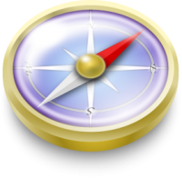
Compass DirectionThe Story of the Explorer’s Compass
Imagine. You are an explorer standing exactly on the North Pole.
It’s been a long journey and it’s freezing cold.
You pull out your compass.
What direction would the needle on the compass point?
The answer may not be what you think.
In order to answer this question, you will have to understand the difference between the true geographic north and magnetic north.
Because these two north locations are completely different.

What is the Geographic (True) North Pole?

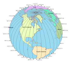
Lines of Longitude
The Earth rotates on the geographic north and south poles. The geographic north and south poles are where lines of longitude (meridians) converge in the north. The south and north pole are directly opposite to one another.
The North Pole is located in the middle of the Arctic Ocean. Scientists have tried marking the North pole. Because the water here is permanently covered with moving sea ice, it’s practically impossible to construct any type of permanent station at the true North Pole.
On the other side of the Earth, the South Pole lies on a continental land mass known as Antarctica. Because the ice on top of Antarctica moves only a few meters a year, the United States Antarctica program has installed a marker here to delineate the true South Pole.
What is the Magnetic North Pole?
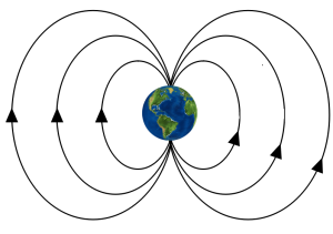
The Earth is one big magnet.
The Magnetic North Pole (also known as the North Dip Pole) is a point on Ellesmere Island in Northern Canada where the northern lines of attraction enter the Earth.
A compass needle rests freely in its casing so it can maneuver itself. When you pull out a compass, it aligns itself with the Earth’s magnetic field. The small magnetic pin is how a compass responds to Earth’s magnetism.
This means that a compass needle will point to the Magnetic North Pole – which is different from the geographic north.
But how much of a difference is the magnetic north vs geographic north?
Earth Magnetic Field

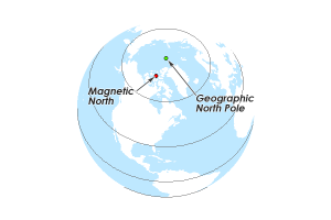
Where are the Magnetic North Pole and Geographic North Pole?

Magnetic North Pole
The question is:
Where would a compass needle point if you were standing on the true North Pole?
If you were standing on the geographic north pole holding your compass, it would point towards northern Canada at Ellesmere Island. This is a difference of about 500 kilometers between the Geographic North and Magnetic North poles!
This difference is called the magnetic inclinationMagnetic deviation is the error of a compass needle including nearby metallic objects.
Magnetic inclination varies according to where you are located on the globe. In order to point you in the right directions, users can compensate for magnetic inclination by using charts of declination or local calibration.
The difference today is about 500 kilometers. But the Magnetic North Pole is actually moving kilometers every year. This phenomenon is known as the Polar Shift Theory.

Polar Shift Theory: Earth’s Ever-Changing Magnetic North Pole

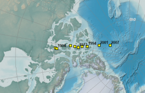
Magnetic North Shift
Magnetic North Shift (Image courtesy of NOAA)
The world we live on is dynamic. Earth is changing every day.
Plate tectonics push continents apart, sea levels fluctuate up and down, volcanoes erupt discharging ash and smoke…
These are examples of natural phenomena that occur in cycles and are dynamic on our planet. The location of our magnetic north is really no different.
Over the last 150 years, the magnetic pole has crept north over 1000 kilometers. Scientists suggest it migrates about 10 kilometers per year and can even flip from pole-to-pole. Lately, the speed has accelerated to about 40 kilometers per year and could reach Siberia in a few decades.
NOAA’s historical declination map shows lines of constant magnetic declination (isogonic lines). Isogonic lines are an indication for what direction compass needles will point – along the lines of magnetic force.

Polar Reversals: South-Pole Pointing Compass

Imagine your compass pointing south instead of north.
Compass
If you were alive to see it 800,000 years ago, it would have been the Magnetic South Pole.
It takes 200,000 to 300,000 years for Earth’s magnetic field to flip polarity. Flipping polarity means the lines of attraction that enter the Earth would flip north to south pole, or vice versa.
This means that it has been twice that long since the last reversal. Some believe we are long overdue for a pole reversal.
But there’s really no need to panic:
NASA scientists say a reversal happens over hundreds or thousands of years. It’s not exactly a clean back flip that happens like a flick of a switch.

Why Does the Earth Have a Magnetic Field in the First Place?

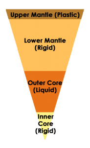
Earth Core
The Earth consists of a solid iron core. Surrounding the iron core is an ocean of hot, liquid metal. The liquid metal that flows in Earth’s core creates electrical currents, which in turn creates our magnetic field.
Unlike a solid fridge magnet, the liquid metal surrounding the inner core moves freely. This explains why the magnetic pole can migrate.
Although geophysicists cannot measure the inner core directly, this is why there is a strong belief that the matter governing Earth’s magnetic field moves around.

Magnets, Compasses and North Bearings

The Geographic North Pole differs from the Magnetic North Pole by about 500 kilometers.
The Geographic North Pole is where lines of longitudes converge into what we call the North Pole. The Magnetic Pole is a point in Northern Canada where the northern lines of attraction enter the Earth.
A compass needle will point to the direction of the Magnetic North Pole. But this doesn’t mean that a compass always points to the Geographic North Pole. This difference is magnetic inclination.
The Earth’s magnetic north is changing every day because of the hot, liquid metal that surrounds the inner core. It can change so much that the Earth’s magnetic field can flip polarity. This is called the Polar Reversal Theory.
Next time you’re out in the woods with your compass, don’t forget about the small magnetic pin that moves freely in the direction of the Magnetic North Pole.

Rank

seo