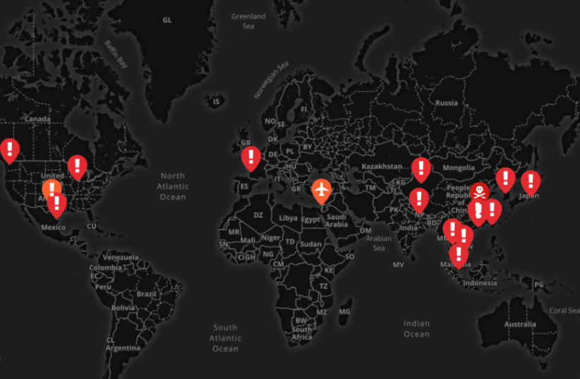
Thousands of people are thought to have been infected in China and around the world.

A map of the deadly Coronavirus outbreaks
(photo credit: SCREENSHOT / MAPHUB)
56 people in China have died and more than 2,000 have been infected by the dangerous coronavirus, and now, several Israelis have reportedly been hospitalized in Sheba Medical Center with the suspicion that they may have caught the frightening virus.
The Israelis had returned from China not long ago.
35 million people, greater than the population of Texas and nearly the population of the state of California, have been placed under quarantine, as the Chinese authorities locked down 12 cities in an attempt to halt the spreading of the deadly coronavirus, The New York Times reported on Sunday.
According to the Times, more than 900 cases of the virus have been confirmed in China, and 26 people have died as of late Friday night. As of Saturday, more than a thousand cases of the virus were reported in China and at least 41 people have died.
Patients carrying the virus were also detected in Hong Kong, Taiwan, Japan, Vietnam and Thailand.
France reported its first three cases late Friday night. An analysis by Imperial College London estimated a total of 1,723 cases in the Chinese city of Wuhan, the center of the outbreak, last week.
Starbucks closed all of its outlets in Hubei province for the week-long Lunar Chinese New Year, Reuters reported.
According to Financial Review, six people in Australia were in quarantine on Friday and tested for the virus.
Malaysia said on Saturday that it had confirmed three cases of coronavirus infection, according to Reuters. Health Minister Dzulkefly Ahmad said the three individuals infected were related to the 66-year-old man that was confirmed by Singaporean health authorities to have tested positive for the virus.
Three cases of the virus have been diagnosed in the United States, with another suspected case being reported in Texas.
On Sunday, a traveler from Wuhan, China was place in isolation in a hospital in Orange County, according to Reuters. The person was reportedly in good condition.
A woman in her sixties from Chicago who had recently been to Wuhan was diagnosed with coronavirus, as well as a man in his thirties from Washington State, near Seattle.
According to the Times, the Center for Disease Control and Prevention (CDC) reported that 63 patients in 22 states were under investigation for the virus, with 11 of them testing negative. Another case of the virus was reported last week in Mexico, in the city of Reynosa that borders the United States.
According to the Times, more than 900 cases of the virus have been confirmed in China, and 26 people have died as of late Friday night. As of Saturday, more than a thousand cases of the virus were reported in China and at least 41 people have died.
Patients carrying the virus were also detected in Hong Kong, Taiwan, Japan, Vietnam and Thailand.
France reported its first three cases late Friday night. An analysis by Imperial College London estimated a total of 1,723 cases in the Chinese city of Wuhan, the center of the outbreak, last week.
The only lab in China designated for researching some of the world's most dangerous pathogens is located in the city, 20 miles away from the Huanan Seafood Market which is believed to be the outbreak's epicenter.
According to The Daily Mail, Chinese scientists warned in 2017 that a SARS-like virus might escape the lab, possibly infecting the area's residents.
Starbucks closed all of its outlets in Hubei province for the week-long Lunar Chinese New Year, Reuters reported.
Australia declared on Saturday its first confirmed case of the Wuhan coronavirus in the state of Victoria, with the patient hospitalized in stable condition in a suburb of Melbourne, Victoria health officials said on Saturday.
According to Financial Review, six people in Australia were in quarantine on Friday and tested for the virus.
Malaysia said on Saturday that it had confirmed three cases of coronavirus infection, according to Reuters. Health Minister Dzulkefly Ahmad said the three individuals infected were related to the 66-year-old man that was confirmed by Singaporean health authorities to have tested positive for the virus.
The newly-identified coronavirus can cause pneumonia, which has been deadly in some cases. It is still too early to know just how dangerous it is and how easily it spreads between people.
Three cases of the virus have been diagnosed in the United States, with another suspected case being reported in Texas.
A woman in her sixties from Chicago who had recently been to Wuhan was diagnosed with coronavirus, as well as a man in his thirties from Washington State, near Seattle.


